Pantanal: reduction in flooded area has led to an increase in fires, study shows
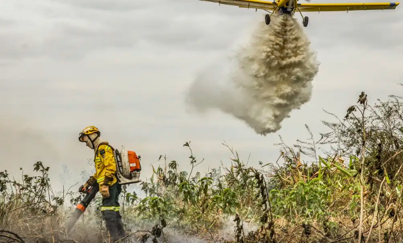
On National Pantanal Day, this Tuesday (12), there is nothing to celebrate, especially this year, when there was an explosion of fires that hit this important Brazilian biome, located in the states of Mato Grosso and Mato Grosso do South.
Research by MapBiomas, released this Tuesday, shows that the flooded area of the Pantanal has been decreasing in recent decades. The reason is that periods of floods are becoming shorter and periods of drought are becoming longer and longer. The result is a greater favor for the occurrence of more intense fires in the largest floodplain in the world.
“With 3.3 million hectares of flooded area, last year was 38% drier than 2018, when the last major flood in the biome occurred, which covered 5.4 million hectares. This area, however, was already 22% drier than that of 1988 (the first major flood in the MapBiomas historical series, which covered 6.8 million hectares)”, says the study by MapBiomas, a collaborative network of universities, NGOs and technology companies, focused on monitoring changes in land cover and use in Brazil.
With Alckmin and Marina, Brazil opens space for social participation at COP29
The space, which has as its theme “Pathways for Ecological Transformation”, is a place for meetings, dialogues and presentation of Brazilian initiatives to combat climate change
The data relates to the period from 1985 to 2023. In the Pantanal, the flood generally occurs from February to April, and the drought, from July to October. The study also indicates that, in 2023, the reduction in water volume was 61% in relation to the historical average for the period analyzed.
The areas flooded for more than three months of the year also show a tendency to reduce, that is, the biome has presented a smaller flooded area at the same time that the flooding has a shorter residence time. The phenomenon has impacted the increase in the savannah area in the Pantanal. Of the current savanna area, which is equivalent to 2.3 million hectares, 22%, around 421 thousand hectares came from places that dried up.
According to the study, this change in the pattern of floods and droughts has effects on the incidence of fires in the biome. In the period between 1985 and 1990, the areas affected by fires corresponded to natural areas in the process of conversion and consolidation of pasture. After the period of the last major flood analyzed, in 2018, there was a recurrence of fires around the Paraguay River.
“From 2019 to 2023, fire has reached places that at the beginning of the mapping series, from 1985 to 1990, were permanently flooded, but which are now experiencing prolonged periods of drought. The total burned from 2019 to 2023 was 5.8 million hectares and the region most affected were precisely those areas that were previously permanently flooded around the Paraguay River”, says the study.
The increase in the number of fires was also confirmed this year by data from the BDQueimadas platform, available on the National Institute for Space Research (Inpe) website. In June, Inpe pointed out that fire outbreaks in the Pantanal increased by more than 1,000% in the first half of this year compared to 2023.
The Inpe satellite detected 978 outbreaks from the first day of the year until June 5th. In the same period last year, there were 95. This year, Mato Grosso do Sul registered 521 fire points and Mato Grosso, 457.
Exotic pastures
The data also showed an increase in exotic pastures, which highlights the expansion in the deforestation process in the Pantanal, for conversion into pasture areas. This changes the dynamics of the water, according to the coordinator of mapping the Pantanal biome at MapBiomas Eduardo Rosa.
“The Pantanal has already experienced prolonged dry periods, as in the 1960s to 1970s, but today it is another reality, of intensive agricultural use and replacement of natural vegetation with areas of pasture and agriculture, mainly on the BAP plateau (Upper Paraguay Hydrographic Basin), which changes the water dynamics in the river basin,” said Rosa.
Anthropogenic use
The study also shows that there has been an increase in anthropogenic use, which concerns actions carried out by humans, especially in BAP. This basin integrates the Cerrado and Amazon biomes and plays a fundamental role in the hydrology of the Pantanal plain.
In 1985, anthropogenic use of BAP lands corresponded to 22% of the total, last year this percentage already reached 42%. The most affected area was the BAP plateau, which had 83% of all anthropogenic use of the river basin, in the period between 1985 and 2023.
Composed of plateaus, mountains, plateaus and depressions, the plateau gradually saw its vegetation converted to pasture and agriculture. During this period, pastures and agriculture occupied 5.4 million hectares, of which 2.4 million hectares were forests and 2.6 million hectares were savanna formations.
“The main anthropic use of the BAP plateau is pasture, which accounts for 77% of the total or more than 11.4 million hectares, followed by agriculture and mosaic of uses, which together represent 20% (3.1 million hectares ) of anthropogenic use in BAP”, says the study.
In the plain region, the loss of natural areas was less intense and more recent. In total, 1.8 million hectares of natural vegetation were removed between 1985 and 2023, of which almost 859 thousand hectares were grasslands and flooded fields, 600 thousand hectares of savannah and 437 thousand hectares of forest.
The study also shows that, between 1985 and 2023, exotic pastures in the Pantanal plain increased from 700 thousand hectares to 2.4 million hectares, increasing precisely over the suppressed natural areas. More than half (55%) of the increase in exotic grassland on the plain has occurred in the last 23 years. In the Pantanal plain, 87% of exotic pastures have low and medium vegetative vigor.